Windows
Mac
Windows
Log in / Sign up
Windows
›
Tags › aerial images
Featured
Aerial Images
Software
Relevance
Popularity
Rating
MapInfo Professional
19,171
Pitney Bowes Software Inc.
This program lets you present information from different sources in a map...
Maps are a very useful and clear way to present data. This program lets you present
Photo Stamp Remover
16,650
SoftOrbits
Photo Stamp Remover can remove people, buildings, watermarks, date stamps, wires, and other unwanted objects...
watermarks to the output
images
AutoCAD Raster Design
2,418
Autodesk Inc.
AutoCAD Raster Design is a comprehensive software program used to create, edit and analyze 3D projects...
able to erase raster
images
, lines, arcs ...and polylines from raster
images
and convert
Ultimate Maps Downloader
981
Lizard Labs
Ultimate Maps Downloader is a detailed mapping software that allows you to download map...
in one big map
image
for offline use...and tiles in several
image
formats. You can select
Trimble Installation Manager
free
980
Trimble Navigation Ltd
Trimble Installation Manager allows you to install and update supported...
Trimble Access software applications,
Aerial
Imaging
software, Trimble Field Link
Didger
521
Golden Software
Didger is a geoprocessing and data conversion tool for any map maker...
and/or mosaicking
aerial
photos or scanned
images
. Overlaying vector
TopoFusion
166
TopoFusion
TopoFusion is GPS Mapping software for Windows OS. It downloads maps (Topo...
downloads maps (Topo,
Aerial
Photo...any imported
image
, with transparency
Easy Ovi Maps Downloader
102
AllmapSoft
Easy Ovi Maps Downloader can automatically download Ovi Maps (Nokia maps, here maps) images to your PC...
to view the download
images
. You can...the small
images
into a larger map
image
using
ERDAS ECW JPEG 2000 Plug-in for Internet Explorer
free
91
Intergraph Corporation
The ECW JPEG 2000 Plug-in allows high-quality aerial photography...
in allows high-quality
aerial
photography...from ERDAS APOLLO Essentials
Image
Trimble Aerial Imaging
63
Trimble Navigation Ltd
Trimble Aerial Imaging is a program designed for planning your aerial missions, performing pre...
Trimble
Aerial
Imaging
is a program designed for planning your
aerial
missions, performing
AirPhotoSE
free
31
TUVSW
AirPhotoSE offers essential features needed for rectification of oblique aerial imagery with geo-referenced output...
of a large
image
simultaneously. Automatic correction...program for combining
aerial
images
with maps
Getmapping Viewer
free
19
Getmapping plc
Getmapping Viewer is an easy to use aerial photo and mapping viewer featuring...
an easy to use
aerial
photo and mapping...com for demo
images
. View local
images
larger than 4GB
PHOTOMOD GeoMosaic
free
12
Racurs
PHOTOMOD GeoMosaic is intended for working with various types of digital images...
of digital
images
, including
aerial
and space...of raster
images
; - Transforming
images
French Sketches Free Screensaver
free
9
Mega-Screens.com
French Sketches is a nice screensaver which shows multiple images of France...
multiple
images
of France: landscapes, buildings, monuments, cathedrals,
aerial
city
TerraExplorer Plus
4
Skyline software systems Inc.
With TerraExplorer Plus, you can overlay the terrain with imagery layers containing geo...
geo-referenced, satellite or
aerial
images
and replace
1
2
3
Tags
Satellite
Images
Maps
Aerial
Mapping
Download map
Map downloader
Aerial photo
Photo
Image
Featured stories
See all
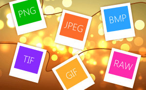
So Many Image Formats
How often do you pay attention to the format of the picture you are downloading? I would guess you almost never do. But do you know how many of them...
Protect Your Images With Watermarks
When you sharing your photos and pictures on the Internet, you can't be too sure whether they're used properly and are not stolen from you and...
Take a Better Screenshot Image with Snagit, Jing and Skitch
Take a peek at the three most popular screen capture applications and pick up the best one.
5 Best AI image generators in 2022
We have gathered five services based on neural networks that will help you create your own bizarre and captivating images.
Logitech offers a hardware-driven way to make use of AI
One of the world's biggest hardware makers seeks to make AI closer to everyone with the help of a button.